October 26, 2022

A Rich Inheritance

A Rich Inheritance 

To celebrate Islamic History Month, I thought I would share this recent beautiful donation we have received at the Museum. This Persian carpet was made in the city of Naeen, Iran, likely in the late 1940s or early 1950s. Naeen workshops are known for making intricately designed carpets that feature a light-coloured background, often using blue as a contrasting colour. The carpets are woven and knotted on a cotton thread foundation with wool fibres, highlighted with light silk accents. 

Photograph taken from above. The large Persian carpet has been laid out. Along the lower right edge the Museum conservator kneels, carefully vacuuming a section of carpet through a mesh screen.

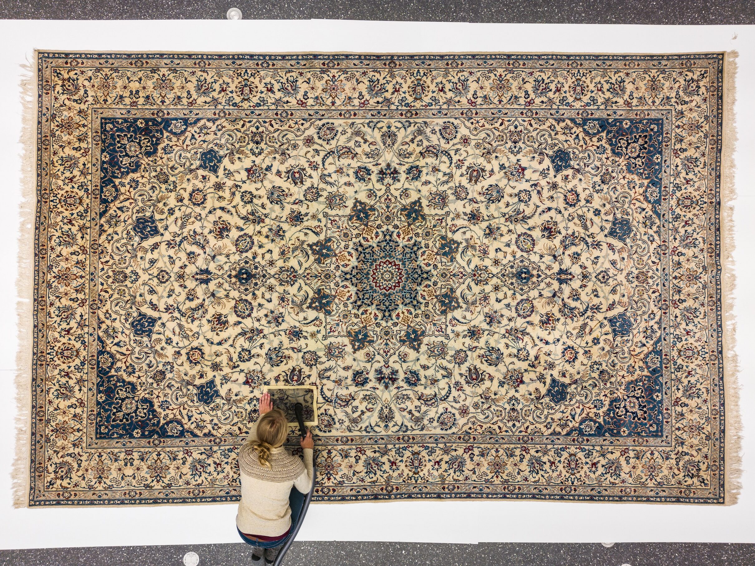
The Museum conservator carefully vacuums the carpet. The carpet is very large (16 x 10.5 feet)  and has many floral and bird motifs placed in symmetrical positions around a luxurious central medallion. At a count of 224 knots per square inch, the carpet has about 5,419,000 knots in total!  H9-40-33 

A close-up on the wool of the woven Persian carpet. A metal object is used to push some of the carpet aside, showing the white fibres amongst the wool fibres.

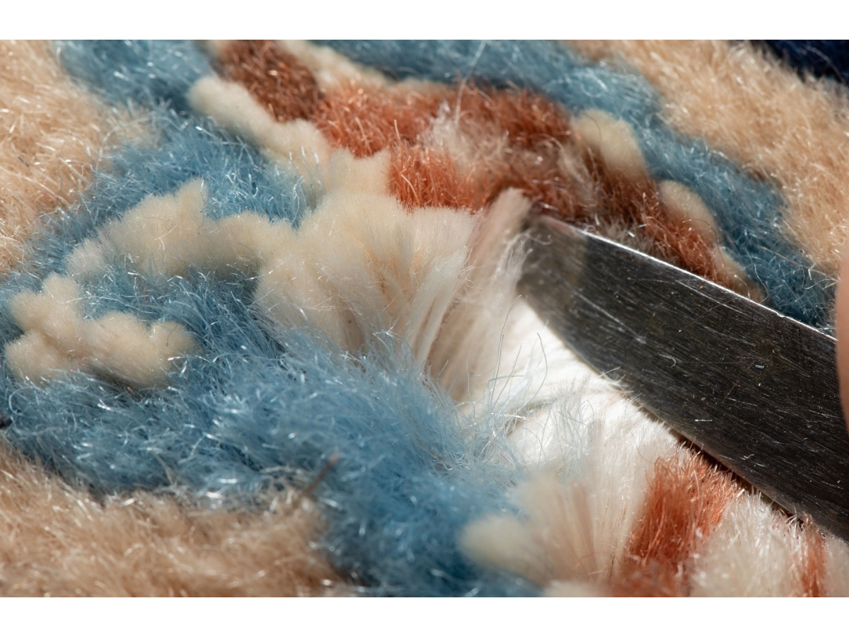
The shining white silk fibres stand out from the surrounding colourful wool. 


Persian carpets have a long history of excellence spanning centuries, and town manufacturers in particular are famous for perfectionism. The Naeen carpet industry began in the 1940s, and designers there were influenced by historic patterns from Isfahan, 150 km to the west. Isfahan flourished artistically during the Safavid dynasty (1501 to 1722). 

Islamic cultures from around the world are incredibly diverse, with long histories that have influenced many parts of the globe. Winnipeg is home for many people who continue to honour and celebrate these histories. This carpet was donated by Zahra Sahhafnia, who moved to Winnipeg in 2015. The carpet was an important part of her family’s legacy and inheritance, and now it is also part of Manitoba’s history.

Thank you Zahra! 

Dr. Roland Sawatzky

Dr. Roland Sawatzky

Curator of History

Roland Sawatzky joined The Manitoba Museum in 2011. He received his B.A. in Anthropology from the University of Winnipeg, M.A. in Anthropology from the University of South Carolina, and Ph.D. in Archaeology…
Meet Dr. Roland Sawatzky

Winnipeg Grotesque

Gargoyles once roosted above the streets of historic Winnipeg, and if you look closely a few might still linger, jeering at passersby. The best set of Winnipeg gargoyles, or in this case “grotesques,” were found on the old Winnipeg Tribune Newspaper building, and the Manitoba Museum is now home to four of them.

The six-storey Tribune building was designed by Chicago architect John D. Atchison for the successful Winnipeg Tribune newspaper, completed in 1914. It was remodelled in 1969 to look more modern, and the grotesques were removed and given to various employees. The Tribune closed in 1980, after which the building was demolished.

Most of the grotesques are still in private hands and have moved around the country, but two of the original terra cotta figures can be seen in the Winnipeg Gallery. We have also added four replicas to one of our buildings in the Winnipeg 1920 cityscape.

Black and white photograph of a rectangular six-story office building. Accent pillars rise up between each column of windows and there is a grotesque at the top of each, and a grinning head at the bottom.

The Winnipeg Tribune Building, 1914, built at 257 Smith St. Fourteen grotesques lined the top of the building, while fourteen heads stared down from the top of the first storey. Image: University of Manitoba Libraries

Architectural sketch showing a crouching grotesque on the building from the front and from the side.

In his design, Atchison sketched in grotesque figures leaning off the top of the building. The final grotesques were made with terra cotta, a type of ceramic, in the American Terra Cotta and Ceramic Co. factory in Illinois. Image: Archives of Manitoba

Architectural sketch showing a grotesque head on the building from the front and from the side.

The heads were located at the bottom of exterior columns. Atchison included neo-Gothic elements in some of his designs, and such grotesques completed the look. Image: Archives of Manitoba

Grotesques and gargoyles were originally found on medieval cathedrals, but here we see them on a business in downtown Winnipeg in 1914. Why? There were six original figures on the Tribune that repeated, making a total of fourteen.

Beige-coloured terra-cotta figure sitting perched on something, holding scissors in one hand and a sheet of paper in another.

Each of the six figures was representative of a newspaper job: 

  • City Editor, complete with scissors (pictured. MM H9-37-581) 
  • The Printer, holding an ancient printing press 
  • The Fish Story Teller, holding a huge fish. 
  • This likely represented a keen member of the public embellishing a story for a reporter. 
  • The Contributor (reporter) 
  • The Proof Reader 
  • Newsboy 

Oddly, the grotesques were all wearing medieval clothing, complete with cloaks and pointy shoes! In other words, it was a whimsical affair – a modern office building with a gothic flair. There was even a legend that the figures resembled the  actual people working at the paper.

Frightening Fact!

A gargoyle is a stone figure that also acts as a waterspout to carry rainwater away from the building – the water is usually funneled out of the mouth of the figure. The word gargoyle comes from the Old French gargouille, meaning “throat.” Other decorative figures on buildings are known as grotesques.

Dr. Roland Sawatzky

Dr. Roland Sawatzky

Curator of History

Roland Sawatzky joined The Manitoba Museum in 2011. He received his B.A. in Anthropology from the University of Winnipeg, M.A. in Anthropology from the University of South Carolina, and Ph.D. in Archaeology…
Meet Dr. Roland Sawatzky

The Story of Yee Chung Yen 

Last year the Rempel-Ong family donated the “Head Tax” Certificate of Yee Chung Yen, a distant relative. The family and Museum staff have been able to piece together some parts of his personal history. 

Yee Chung Yen (1895-1982), later known as Henry Yee, was born in Longgang, Shenzhen District, China, and immigrated to Canada in 1917. He was forced to pay a $500 “Head Tax” to enter the country, part of a racist Canadian policy to restrict Chinese immigration. By the time the Canadian Pacific Railway was completed back in 1885, over 15,000 Chinese labourers had come to Canada to work on this difficult, nation-building project. After the work was done, restrictions were put in place to severely limit Chinese immigration. The “Head Tax” was implemented from 1885 until 1923, and was then replaced by the Chinese Exclusion Act, which barred all Chinese immigration until 1947. In 2006, Prime Minister Stephen Harper apologized for these discriminatory laws and the hardship they created for Chinese Canadians.  

Despite the burdens of the Head Tax and Chinese Exclusion Act, Yee Chung Yen persevered. By 1923 he was working at the Subway Café at 250 Osborne St in Winnipeg, which was managed by a Mr. Yee Too. Yee Chung Yen later owned Yee’s Café in Portage la Prairie in the 1950s. The Chinese Exclusion Act had severe consequences on his personal life. Yee Chung Yen was married in China before he arrived in Canada in 1917, and the couple had two children, but Yen would never see his family again.  From 1923 to 1947 his wife and children were barred from entering the country because of the Exclusion Act, Yen was never able to return to China, and they didn’t reunite afterwards.  

Photograph of a Head Tax Certificate. Along the top reads, “Dominion of Canada / Immigration Branch – Department of the Interior”, and in the bottom right corner is a identifiaction photo of a serious-looking young man wearing a dark suit.

Head Tax Certificate of Yee Chung Yen, 1917.

Surviving certificates are extremely rare today, and they help tell the story of resilient Chinese immigrants from the early 20th Century who were subjected to discriminatory Canadian policies and attitudes. H9-39-967 

Photograph of the backside of a piece of paper. In the centre is stamped, “IMPORTANT / It is necessary that this certificate be carefully preserved as it is of calue as a means of identification”. In the bottom left corner is a registration number and certification stamp, date, and signature.

Head Tax Certificate, 1917 (reverse).

On the back of the certificate is the 1923 Chinese Immigration Act (or Chinese Exclusion Act) registration stamp. It indicates that Yee Chung Yen was registered and under observation by Canadian authorities. The Act came into effect on July 1. Though other Canadians celebrated Dominion Day at that time, Chinese Canadians called it “Humiliation Day.”

Like other Chinese immigrants, he was not allowed to bring family to live with him in Canada, and his movement outside of the country was strictly regulated. This system was in use for all Chinese Canadians until 1947. H9-39-967 

Yen was instrumental in helping Mr. Don Wing Ong settle in Portage la Prairie in the 1950s. Refugees from mainland Communist China, Don and his wife Kwan (Anne) and their son Bill made it to Hong Kong, and would eventually all live and work in Winnipeg. Bill graduated from medical school at the University of Manitoba and became a well-respected doctor in the city.  When Yee Chung Yen became ill and then died in 1982, Don paid some of the medical bills and the funeral expenses. Don quietly visited the grave of Yee Chung Yen at Brookside Cemetery every year until Don’s own passing in 2019.

Six historical photographs documenting the life of Yee Chung Yen from childhood to adulthood.

These photographs document the life of Yee Chung Yen (1895-1982).

Clockwise from top left: 
1. Circa 1900. Yee Chung Yen with mother in China. H9-40-10 
2. 1920 in Victoria, BC. H9-39-988 
3. 1923, working at the Subway Café on Osborne St., Winnipeg, MB. H9-39-984 
4. 1930s. H9-39-994 
5. Circa 1952, at Yee’s Cafe, Portage la Prairie, MB. H9-39-981 
6. 1970s, Winnipeg. H9-40-3

Photogragh of a citizenship card with identifiaction details and a photograph of an older man wearing a suit and bow tie.

Certificate of Canadian Citizenship, 1960.

Yee Chung Yen (Henry) received full Canadian citizenship in 1960, 43 years after arriving in Canada. H9-39-968 

The story and images of Yen Chung Yee will soon be featured in the Winnipeg Gallery digital kiosk.

Along with pictures and documents related to Yen, the Rempel-Ong donation includes many items that recount the story of the Ong family as they immigrated and settled in Canada.

We hope to feature their story on video soon. 

Dr. Roland Sawatzky

Dr. Roland Sawatzky

Curator of History

Roland Sawatzky joined The Manitoba Museum in 2011. He received his B.A. in Anthropology from the University of Winnipeg, M.A. in Anthropology from the University of South Carolina, and Ph.D. in Archaeology…
Meet Dr. Roland Sawatzky

Time’s Waypoints 

By Dr. Graham Young, past Curator of Palaeontology & Geology

The Deep History of the Churchill Quartzite 

As we pass through life we accumulate scars, each of which tells a story about an event that affected us. This white line on my hand shows where I fell hard on a tree stump in Nova Scotia when I was 19 years old. That pain in my ankle reminds me of an injury from another fall 30 years later, on an oil-slicked seashore. The older we get, the more of these old scars and injuries we will accumulate.  

It is the same in the natural world. Very old natural things, whether they are living or inanimate, carry many sorts of evidence with them. In the case of rocks, this evidence can tell us the stories of all the events that affected a rock between the time it was formed and the present day. 

Manitoba is home to many very old rocks; at least 2/3 of our province has bedrock that is about 1.7 to 3.5 billion years old, dating from the mid part of Precambrian time. Many of these rocks are beautiful and memorable – consider examples such as the granites and schists of the Whiteshell, east of Winnipeg – but to my eye the most memorable is the Churchill quartzite. This is the blue-grey to dove grey stone that forms the sculptural, sinuous “whaleback” ridges on both sides of the mouth of the Churchill River near Hudson Bay, so often seen as the backdrops in photos of polar bears. 


A wide-angle view of a rocky landscape along a shoreline. Many large, scupltural ridges of light-coloured Churchill quartzite.

The Churchill quartzite has long been remarked upon by visitors to the Churchill area. It was first described and named by the Geological Survey of Canada geologist Robert Bell in 1880, and though the name “Churchill quartzite” was assigned so long ago, it has never received a formal scientific description, so the word ”quartzite” is not capitalized.  

The first waypoint of Churchill quartzite’s time travel was its formation. Although it is a “youngster” in comparison with some of the Precambrian rocks east of Lake Winnipeg, it is still deeply old. Somewhere around 1.8 billion years ago, what is now the Churchill area was covered by large rivers that flowed from newly rising mountains nearby. Since the riverbeds were steeply sloped, the rivers carried an abundance of coarse sediment: quartz grains, dark minerals such as mica and magnetite, and fragments of various rocks (some of which could be quite large). 

Close-up of a section of Churchill quartzite that has a rounded white peice of another stone in the middle. From the left edge, a hand holds a size scale into frame. Orange lichen is growing on the surface of the quartzite.

The Churchill quartzite is a metagreywacke, a metamorphosed “dirty sandstone” that can contain large rock fragments such as the rounded white piece in the middle of this photo. 

Where the flow of those rivers slowed, they deposited sediment. The Churchill quartzite contains evidence that it was deposited by flowing water, and that the flow was variable: features known as cross beds were formed as the sediment was laid down on angled or curved surfaces, in places such as river sandbars. Over long intervals of time, this deposited material was buried in more sediment, and pressure from the weight of that sediment turned it to stone. The sand, varied minerals, and rock fragments formed a dirty sandstone, known geologically as a greywacke. 

Close-up of a section of Churchill quartzite with dark scratch-like lines on the surface. Orange and light-green lichen grows long parts of the quartzite. In the upper right corner a size scale is laid on the rock’s surface.

Beautiful trough cross beds can be seen in the Churchill quartzite at Sloop Cove. The dark lines show where grains of heavy minerals such as magnetite were the first to fall out of the water as river flow slowed. 

Through yet more geological time, this greywacke was buried ever deeper, where it was subjected to heat and pressure from the ongoing geological activity in this region. This welded the sediment grains together, giving the rock the remarkable toughness for which it is prized today by people building railways and airports. The greywacke had been metamorphosed and became a metamorphic (changed) rock, the metagreywacke that we call the Churchill quartzite. 

Close-up of the surface of a smooth section of grey Churchill quartzite with a thick twisted quartz vein visible in white.

Twisted quartz veins in the Churchill quartzite show that it was subjected to great heat and pressure. 

As time continued to pass, the nearby mountains were worn flat by erosion, and the tough, deeply buried Churchill quartzite was slowly uplifted until it was again exposed at the Earth’s surface. For many millions of years, this bedrock was subject to the forces of erosion in a desert-like landscape; the rock surfaces were smoothed and weathered, and large boulder fields developed at the bases of quartzite slopes. 

Landscape photo of a rocky shoreline with a incline going up to boulders on the left edge from the waterline on the right edge.

Dolostone from the Ordovician Period was deposited around an ancient boulder field, at the foot of a scarp of Churchill quartzite. The old quartzite island was to the left in this photo, and the Ordovician sea was to the right. This is the site depicted in the Museum’s Ancient Seas exhibit. 

More than a billion years after the Churchill quartzite was formed, another waypoint was added to its time journey. The Churchill region was now near the equator, and a warm sea flowed in and covered the area. Water extended to the horizon in all directions, but the tough ridges of quartzite stood up above the water, so that they formed an archipelago of islands in that tropical sea. 

Map graphic showing the Churchill coastline along the Hudson’s Bay with brown markings along the shoreline where ridges of Churchill quartzite formed islands in the Ordovician tropical sea.

The ridges of Churchill quartzite (brown areas on this map of modern Churchill) formed islands in the Ordovician tropical sea. 

Close-up photo of a rock surface with several fossil corals in it. Along the middle of the left edge a scale card is placed on the rock.

These fossil corals show how tropical marine life proliferated against the quartzite shores. 

Photo of a crevice betweentwo sections of smooth grey rock where a section of uneven and chunky rock has developed.

A crevice in the quartzite scarp is filled with Ordovician dolostone, which is itself full of pieces of weathered quartzite! 

Around these islands, abundant sea life lived: creatures such as trilobites and giant cephalopods swam in the water, while corals proliferated in front of and against the quartzite shores. We see evidence of this sea life in Ordovician and Silurian age dolostones (rocks similar to limestones) and sandstones that date from about 450 to 440 million years ago; in some remarkable instances the fossil-rich rocks fill crevices in the quartzite surfaces!  

The sea became deeper, and during the Silurian and the subsequent Devonian Period, it is likely that the sculpted ridges of Churchill quartzite were again buried, with hundreds of metres of sedimentary rock laid down above them. An immense length of time passed, hundreds of millions of years, the sea was gone, and the thick sedimentary rocks above the quartzite were slowly eroded away by water and wind. 

About two and a half million years ago, a different erosional force arrived in the region. The Ice Age, also known as the Pleistocene glaciation, began, and large continental glaciers began to expand southward from the Arctic. These glaciers eventually covered much of North America, and in places they were two to four kilometres thick! The immense weight of this great thickness of ice gave it immense erosional power, and as it moved slowly southward across the land surface it deeply eroded and scoured the bedrock surfaces. 

Dr. Maureen Matthews staning at the right edge of the frame on a large flat rock in the ground with scratch or scrape-like markings along it.

Striations on a polished quartzite surface show the direction(s) of glacial ice movement. Here, Dr. Maureen Matthews demonstrates striations east of Churchill Airport. 

As was the case during earlier erosion intervals, the immense toughness of the Churchill quartzite meant that it fared better than the other rocks around it. The dolostones that overlaid and abutted the quartzite were heavily ground down, to the extent that they can be observed in only a few select places in the Churchill area. The quartzite ridges themselves, in spite of their hardness, show considerable evidence of glacial erosion: in most places their surfaces were polished by the ice and show striations, lines and grooves that demonstrate the varied directions of ice flow as the rock fragments stuck into the bottom of the glacier scraped the top of the bedrock. 

An individual standing at the top of a tall rocky rise from the sand.

East of Halfway Point, the quartzite ridge along the shore has the features of a roche moutonée: it is curved and polished on the north side (left), while the south side (right) shows many places where pieces of the rock were plucked and carried away by the flowing glacier. 

In some locations you can see other features characteristic of glacial erosion: a roche moutonnée, or sheepback, shows where a large chunk was plucked out of the downstream side of a quartzite ridge, while the upstream side of the same ridge was smoothly polished. Chatter marks are smaller features, crescent-shaped gouges that show evidence of chipping by rock fragments on the base of the glacier; these are typically at right angles to the direction of ice flow (which is itself demonstrated by the striations, or lines on the bedrock surface). 

In southern Canada the Ice Age began to end roughly 12,000 years ago, and by 8,000 years ago the ice in northern Manitoba had melted to the extent that the Tyrrell Sea had formed – this forerunner of Hudson Bay was a huge body of water that covered the low-lying land that had been pushed down by the weight of the glaciers. Our ridges of Churchill quartzite were now again under deep salt water; old beach ridges show that the Tyrrell Sea extended many tens of kilometres south and west of Churchill. 

Photograph focusing on a rocky surface with orange lichen growing near graffiti scratched onto the rock reading, “I•Wood / 1757” and “J. Horner / 1746”. Several people stand out of focus at the top of the frame.

At Sloop Cove, near the 18th century British graffiti, glacial chatter marks are outlined by the growth of orange lichens. 

Landscape photo looking out over a pebbled shoreline. In the distance a jut of land has industrial buildings on it.

Near Fort Prince of Wales, old beach ridges are far above the modern sea level. 

Landscape view over a shoreline overed in large rocks jutting out from the grass. Several individuals scramble about on the rocks.

In the 21st century, there is no way we could overwinter a ship in Sloop Cove. 

This region has been rising ever since, and even today the Churchill area continues to rise at a rate of almost a metre a century! This continued uplift is shown by the relationship between some human structures and the quartzite ridges. For example, old mooring rings at Sloop Cove, near the Churchill River, show where people were able to haul sloops (small ships) out of the river in the 18th century, to protect them from ice during the long northern winter. The cove has risen so much in the past 300 years that there is no way a ship could be hauled out in the same place today! 

Sloop Cove is one piece of the final chapter in the saga of the Churchill quartzite. The sinuous ridges have actually been associated with humanity for several millennia, ever since Pre-Dorset Inuit people living some 3500 years ago hunted marine mammals from what was then an archipelago of quartzite islands in the Tyrrell Sea. More recently, the men of the Hudson’s Bay Company quarried large blocks of this tough stone for construction of the impressive 18th century Fort Prince of Wales and Cape Merry Battery, which flank either side of the mouth of the Churchill River. Those men also carved the names of many men and ships into the cross-bedded quartzite at Sloop Cove. 

Photograph focusing on a rocky surface with orange and light-green lichen growing near graffiti scratched onto the rock. The nearest graffiti reads, “Richard C / T+H 1750 / Geo:Holt / 1771”.

Eighteenth century graffiti at Sloop Cove. 

View over a ridge across green landscape with intermitant evergreen trees towards a quarry site with dust blowing in the wind.

In 2022 a huge amount of Churchill quartzite was being crushed at Airport Cove, to provide ballast stone for improvements to the Hudson Bay Railway. 

Several individuals standing near the site of a ruined building. Some people look over the stone walls, now only a few feet high, into the ruin itself.

Some human usage of Churchill quartzite has been quite whimsical. This structure at Churchill, which looks like an ancient castle ruin, represents a never-completed stone hotel. The walls, built directly onto quartzite bedrock, include cobbles and boulders of many different kinds of stone. 

In the 20th and 21st centuries, Churchill quartzite has been put to many uses by enterprising humans: it makes superb ballast stone for the Hudson Bay Railway, it has been used to construct the large weir that controls flow of the Churchill River, it underlies the runways of Churchill Airport, and it appears as a backdrop in all those wonderful photos and videos of polar bears in their natural habitat! 

What does the future hold, I wonder, for such a remarkable and robust geological formation? In any case, it will be here for many millennia to come. 

This post draws on images and observations from our very successful August, 2022, Museum research trip to the Churchill area, which allowed our group to develop many ideas for new exhibit collaborations. A few of the photos are from earlier paleontological fieldwork in the Churchill area over the past 26 years.