A rocky landscape featuring a large smooth rock of Churchill quartzite on the left side.
October 6, 2022

Time's Waypoints

Time’s Waypoints 

By Dr. Graham Young, past Curator of Palaeontology & Geology

The Deep History of the Churchill Quartzite 

As we pass through life we accumulate scars, each of which tells a story about an event that affected us. This white line on my hand shows where I fell hard on a tree stump in Nova Scotia when I was 19 years old. That pain in my ankle reminds me of an injury from another fall 30 years later, on an oil-slicked seashore. The older we get, the more of these old scars and injuries we will accumulate.  

It is the same in the natural world. Very old natural things, whether they are living or inanimate, carry many sorts of evidence with them. In the case of rocks, this evidence can tell us the stories of all the events that affected a rock between the time it was formed and the present day. 

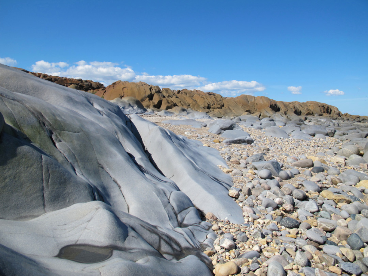
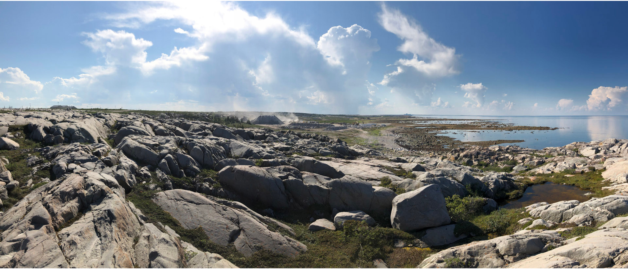
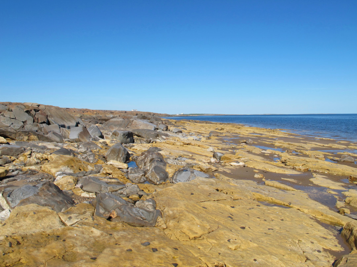
Manitoba is home to many very old rocks; at least 2/3 of our province has bedrock that is about 1.7 to 3.5 billion years old, dating from the mid part of Precambrian time. Many of these rocks are beautiful and memorable – consider examples such as the granites and schists of the Whiteshell, east of Winnipeg – but to my eye the most memorable is the Churchill quartzite. This is the blue-grey to dove grey stone that forms the sculptural, sinuous “whaleback” ridges on both sides of the mouth of the Churchill River near Hudson Bay, so often seen as the backdrops in photos of polar bears. 


A wide-angle view of a rocky landscape along a shoreline. Many large, scupltural ridges of light-coloured Churchill quartzite.

The Churchill quartzite has long been remarked upon by visitors to the Churchill area. It was first described and named by the Geological Survey of Canada geologist Robert Bell in 1880, and though the name “Churchill quartzite” was assigned so long ago, it has never received a formal scientific description, so the word ”quartzite” is not capitalized.  

The first waypoint of Churchill quartzite’s time travel was its formation. Although it is a “youngster” in comparison with some of the Precambrian rocks east of Lake Winnipeg, it is still deeply old. Somewhere around 1.8 billion years ago, what is now the Churchill area was covered by large rivers that flowed from newly rising mountains nearby. Since the riverbeds were steeply sloped, the rivers carried an abundance of coarse sediment: quartz grains, dark minerals such as mica and magnetite, and fragments of various rocks (some of which could be quite large). 

Close-up of a section of Churchill quartzite that has a rounded white peice of another stone in the middle. From the left edge, a hand holds a size scale into frame. Orange lichen is growing on the surface of the quartzite.

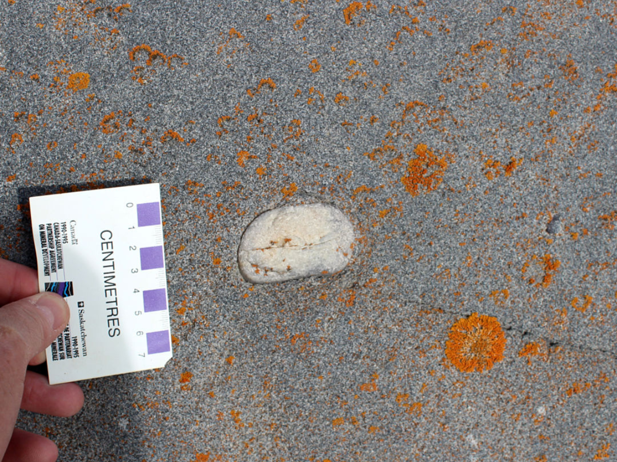
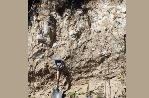
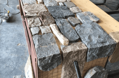
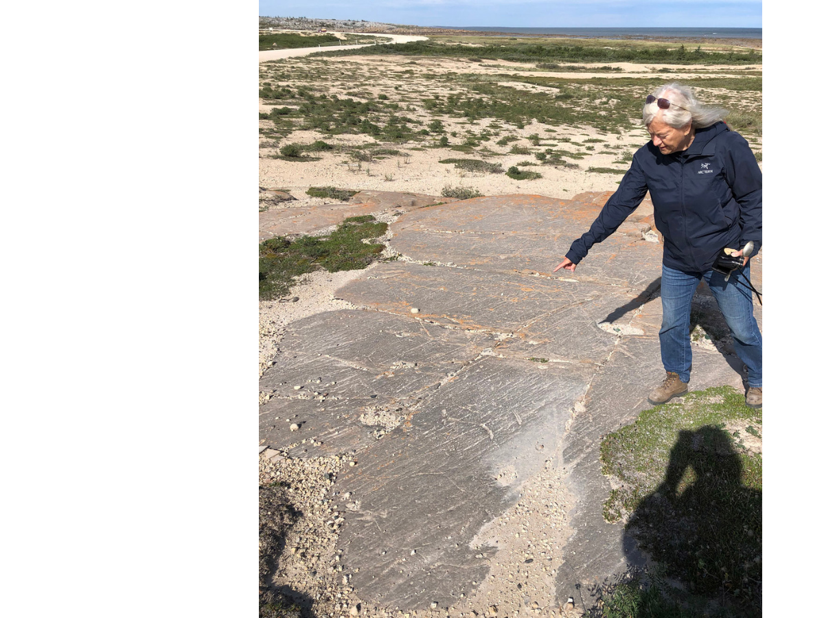
The Churchill quartzite is a metagreywacke, a metamorphosed “dirty sandstone” that can contain large rock fragments such as the rounded white piece in the middle of this photo. 

Where the flow of those rivers slowed, they deposited sediment. The Churchill quartzite contains evidence that it was deposited by flowing water, and that the flow was variable: features known as cross beds were formed as the sediment was laid down on angled or curved surfaces, in places such as river sandbars. Over long intervals of time, this deposited material was buried in more sediment, and pressure from the weight of that sediment turned it to stone. The sand, varied minerals, and rock fragments formed a dirty sandstone, known geologically as a greywacke. 

Close-up of a section of Churchill quartzite with dark scratch-like lines on the surface. Orange and light-green lichen grows long parts of the quartzite. In the upper right corner a size scale is laid on the rock’s surface.

Beautiful trough cross beds can be seen in the Churchill quartzite at Sloop Cove. The dark lines show where grains of heavy minerals such as magnetite were the first to fall out of the water as river flow slowed. 

Through yet more geological time, this greywacke was buried ever deeper, where it was subjected to heat and pressure from the ongoing geological activity in this region. This welded the sediment grains together, giving the rock the remarkable toughness for which it is prized today by people building railways and airports. The greywacke had been metamorphosed and became a metamorphic (changed) rock, the metagreywacke that we call the Churchill quartzite. 

Close-up of the surface of a smooth section of grey Churchill quartzite with a thick twisted quartz vein visible in white.

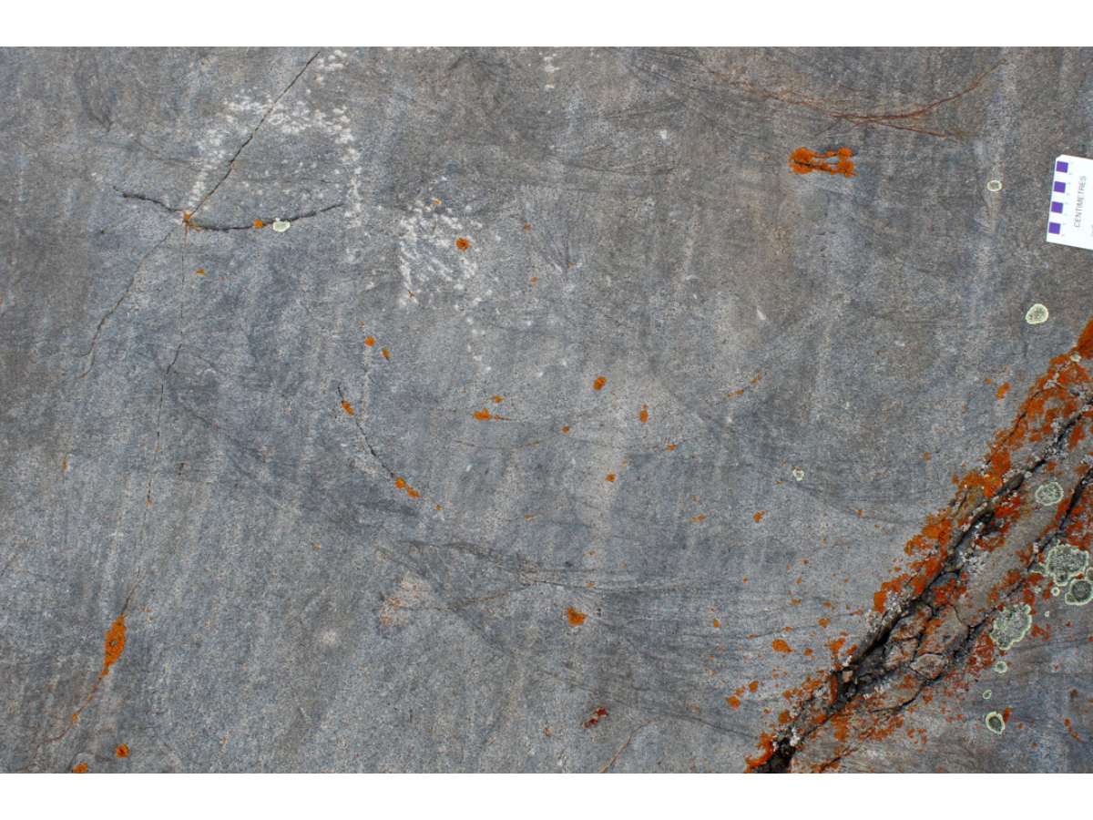
Twisted quartz veins in the Churchill quartzite show that it was subjected to great heat and pressure. 

As time continued to pass, the nearby mountains were worn flat by erosion, and the tough, deeply buried Churchill quartzite was slowly uplifted until it was again exposed at the Earth’s surface. For many millions of years, this bedrock was subject to the forces of erosion in a desert-like landscape; the rock surfaces were smoothed and weathered, and large boulder fields developed at the bases of quartzite slopes. 

Landscape photo of a rocky shoreline with a incline going up to boulders on the left edge from the waterline on the right edge.

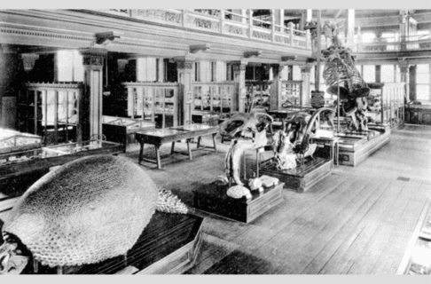
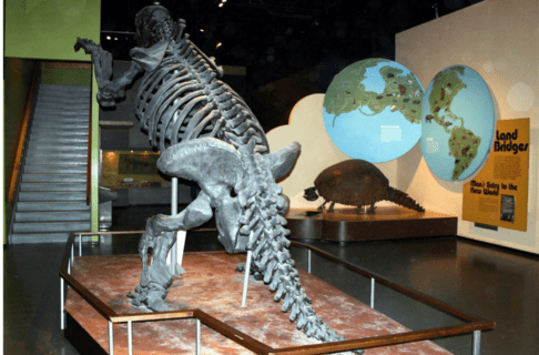
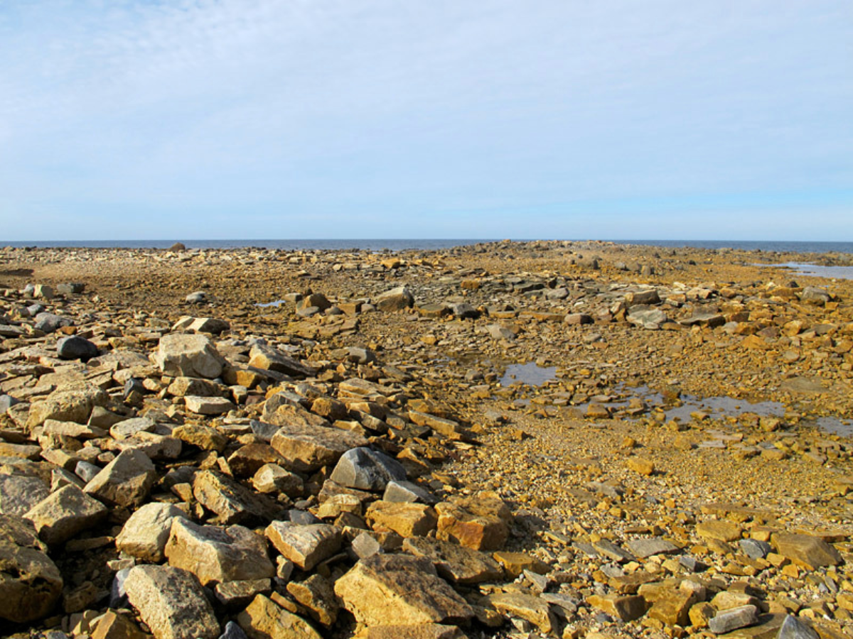
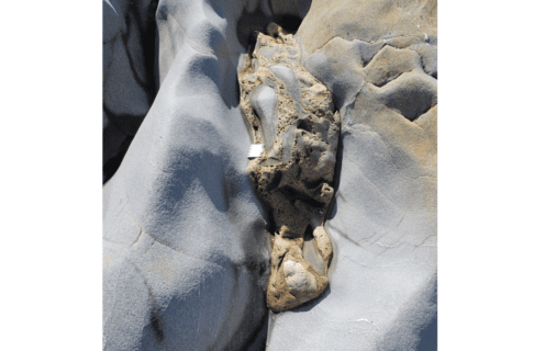
Dolostone from the Ordovician Period was deposited around an ancient boulder field, at the foot of a scarp of Churchill quartzite. The old quartzite island was to the left in this photo, and the Ordovician sea was to the right. This is the site depicted in the Museum’s Ancient Seas exhibit. 

More than a billion years after the Churchill quartzite was formed, another waypoint was added to its time journey. The Churchill region was now near the equator, and a warm sea flowed in and covered the area. Water extended to the horizon in all directions, but the tough ridges of quartzite stood up above the water, so that they formed an archipelago of islands in that tropical sea. 

Map graphic showing the Churchill coastline along the Hudson’s Bay with brown markings along the shoreline where ridges of Churchill quartzite formed islands in the Ordovician tropical sea.

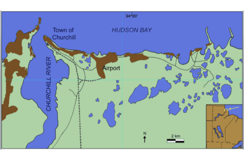
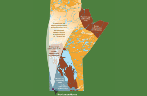
The ridges of Churchill quartzite (brown areas on this map of modern Churchill) formed islands in the Ordovician tropical sea. 

Close-up photo of a rock surface with several fossil corals in it. Along the middle of the left edge a scale card is placed on the rock.

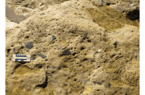
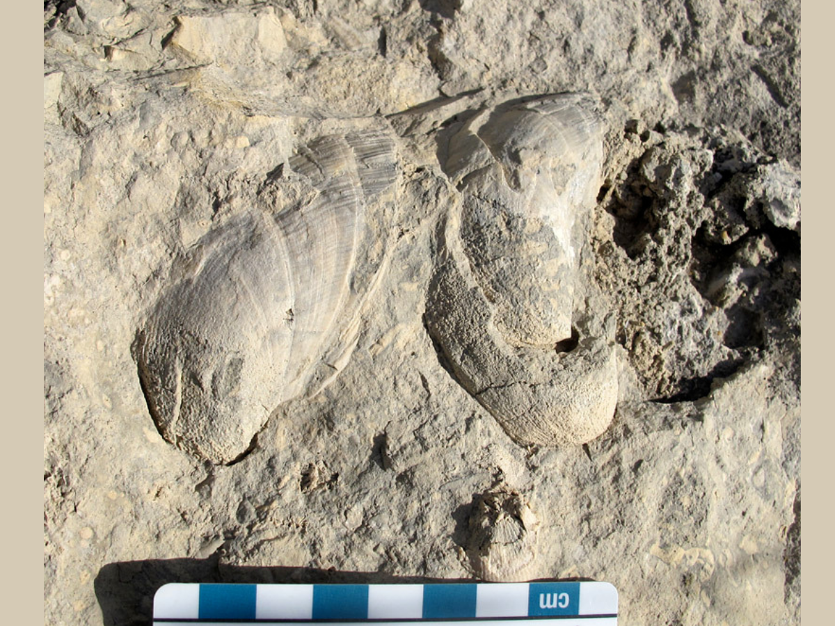
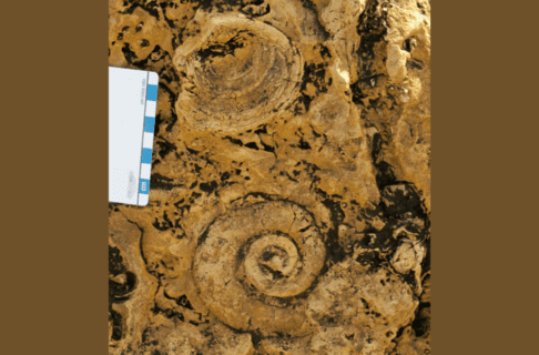
These fossil corals show how tropical marine life proliferated against the quartzite shores. 

Photo of a crevice betweentwo sections of smooth grey rock where a section of uneven and chunky rock has developed.

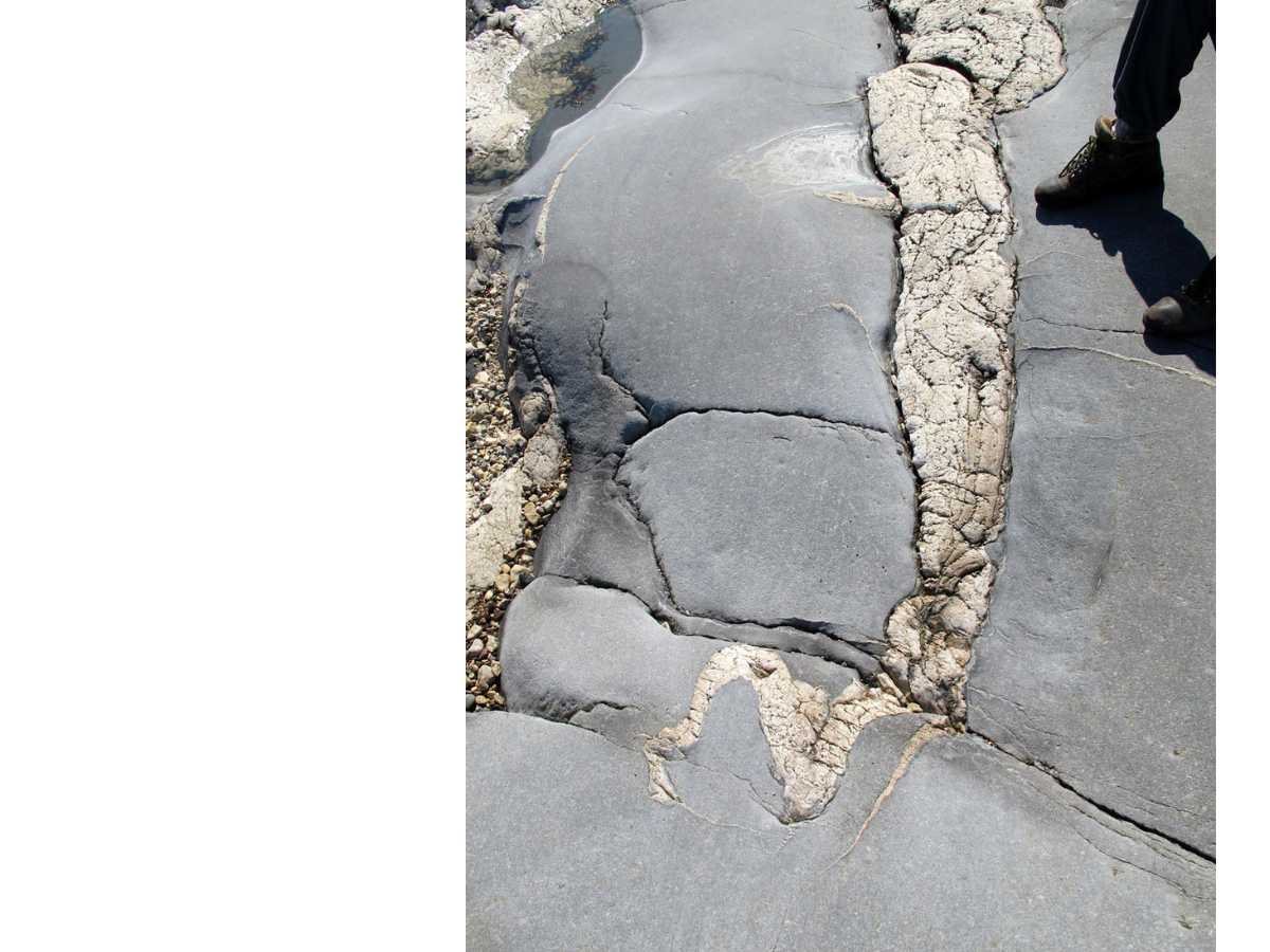
A crevice in the quartzite scarp is filled with Ordovician dolostone, which is itself full of pieces of weathered quartzite! 

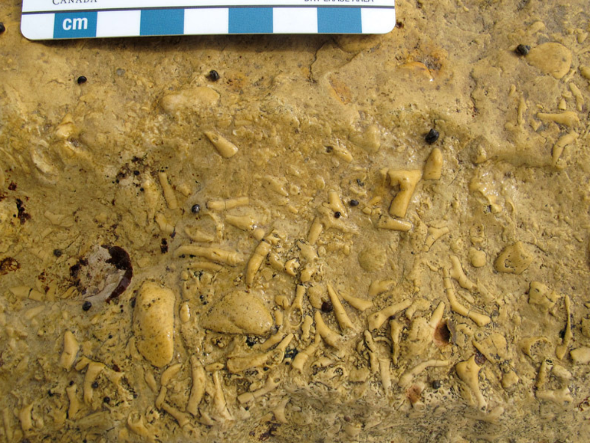
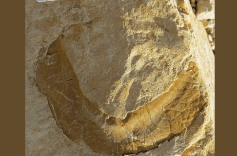
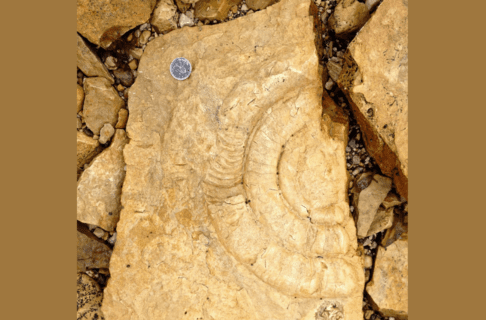
Around these islands, abundant sea life lived: creatures such as trilobites and giant cephalopods swam in the water, while corals proliferated in front of and against the quartzite shores. We see evidence of this sea life in Ordovician and Silurian age dolostones (rocks similar to limestones) and sandstones that date from about 450 to 440 million years ago; in some remarkable instances the fossil-rich rocks fill crevices in the quartzite surfaces!  

The sea became deeper, and during the Silurian and the subsequent Devonian Period, it is likely that the sculpted ridges of Churchill quartzite were again buried, with hundreds of metres of sedimentary rock laid down above them. An immense length of time passed, hundreds of millions of years, the sea was gone, and the thick sedimentary rocks above the quartzite were slowly eroded away by water and wind. 

About two and a half million years ago, a different erosional force arrived in the region. The Ice Age, also known as the Pleistocene glaciation, began, and large continental glaciers began to expand southward from the Arctic. These glaciers eventually covered much of North America, and in places they were two to four kilometres thick! The immense weight of this great thickness of ice gave it immense erosional power, and as it moved slowly southward across the land surface it deeply eroded and scoured the bedrock surfaces. 

Dr. Maureen Matthews staning at the right edge of the frame on a large flat rock in the ground with scratch or scrape-like markings along it.

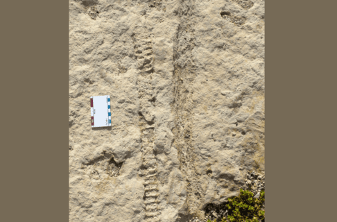
Striations on a polished quartzite surface show the direction(s) of glacial ice movement. Here, Dr. Maureen Matthews demonstrates striations east of Churchill Airport. 

As was the case during earlier erosion intervals, the immense toughness of the Churchill quartzite meant that it fared better than the other rocks around it. The dolostones that overlaid and abutted the quartzite were heavily ground down, to the extent that they can be observed in only a few select places in the Churchill area. The quartzite ridges themselves, in spite of their hardness, show considerable evidence of glacial erosion: in most places their surfaces were polished by the ice and show striations, lines and grooves that demonstrate the varied directions of ice flow as the rock fragments stuck into the bottom of the glacier scraped the top of the bedrock. 

An individual standing at the top of a tall rocky rise from the sand.

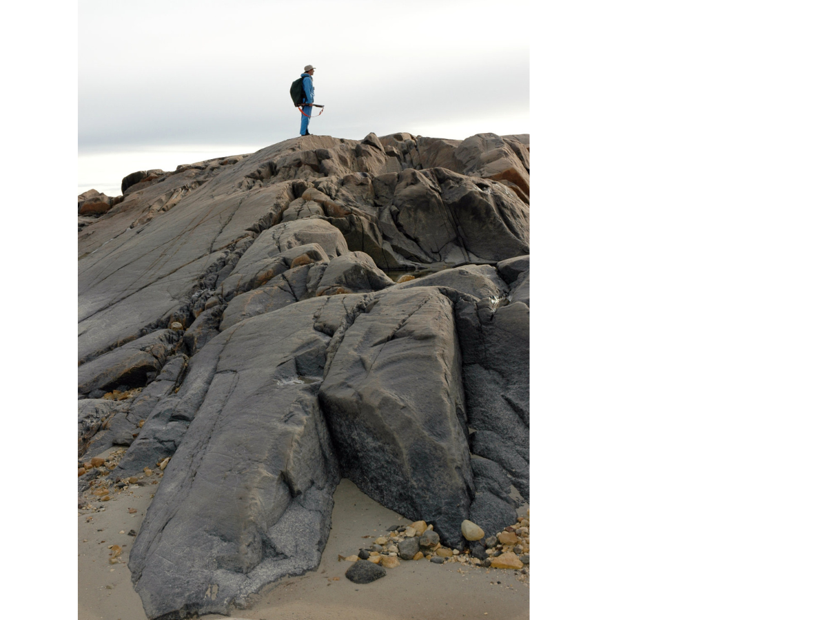
East of Halfway Point, the quartzite ridge along the shore has the features of a roche moutonée: it is curved and polished on the north side (left), while the south side (right) shows many places where pieces of the rock were plucked and carried away by the flowing glacier. 

In some locations you can see other features characteristic of glacial erosion: a roche moutonnée, or sheepback, shows where a large chunk was plucked out of the downstream side of a quartzite ridge, while the upstream side of the same ridge was smoothly polished. Chatter marks are smaller features, crescent-shaped gouges that show evidence of chipping by rock fragments on the base of the glacier; these are typically at right angles to the direction of ice flow (which is itself demonstrated by the striations, or lines on the bedrock surface). 

In southern Canada the Ice Age began to end roughly 12,000 years ago, and by 8,000 years ago the ice in northern Manitoba had melted to the extent that the Tyrrell Sea had formed – this forerunner of Hudson Bay was a huge body of water that covered the low-lying land that had been pushed down by the weight of the glaciers. Our ridges of Churchill quartzite were now again under deep salt water; old beach ridges show that the Tyrrell Sea extended many tens of kilometres south and west of Churchill. 

Photograph focusing on a rocky surface with orange lichen growing near graffiti scratched onto the rock reading, “I•Wood / 1757” and “J. Horner / 1746”. Several people stand out of focus at the top of the frame.

At Sloop Cove, near the 18th century British graffiti, glacial chatter marks are outlined by the growth of orange lichens. 

Landscape photo looking out over a pebbled shoreline. In the distance a jut of land has industrial buildings on it.

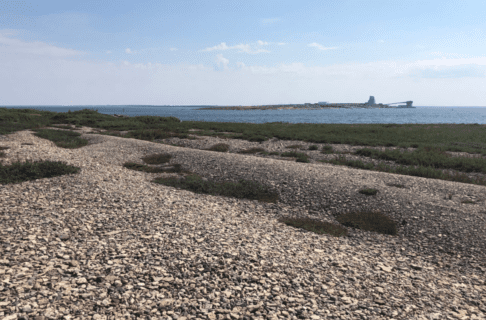
Near Fort Prince of Wales, old beach ridges are far above the modern sea level. 

Landscape view over a shoreline overed in large rocks jutting out from the grass. Several individuals scramble about on the rocks.

In the 21st century, there is no way we could overwinter a ship in Sloop Cove. 

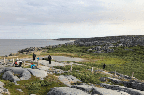
This region has been rising ever since, and even today the Churchill area continues to rise at a rate of almost a metre a century! This continued uplift is shown by the relationship between some human structures and the quartzite ridges. For example, old mooring rings at Sloop Cove, near the Churchill River, show where people were able to haul sloops (small ships) out of the river in the 18th century, to protect them from ice during the long northern winter. The cove has risen so much in the past 300 years that there is no way a ship could be hauled out in the same place today! 

Sloop Cove is one piece of the final chapter in the saga of the Churchill quartzite. The sinuous ridges have actually been associated with humanity for several millennia, ever since Pre-Dorset Inuit people living some 3500 years ago hunted marine mammals from what was then an archipelago of quartzite islands in the Tyrrell Sea. More recently, the men of the Hudson’s Bay Company quarried large blocks of this tough stone for construction of the impressive 18th century Fort Prince of Wales and Cape Merry Battery, which flank either side of the mouth of the Churchill River. Those men also carved the names of many men and ships into the cross-bedded quartzite at Sloop Cove. 

Photograph focusing on a rocky surface with orange and light-green lichen growing near graffiti scratched onto the rock. The nearest graffiti reads, “Richard C / T+H 1750 / Geo:Holt / 1771”.

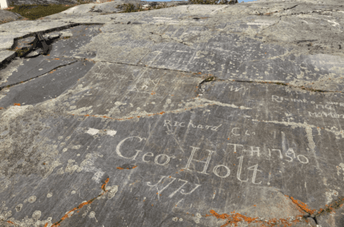
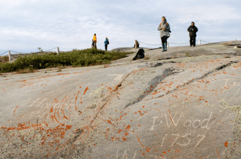
Eighteenth century graffiti at Sloop Cove. 

View over a ridge across green landscape with intermitant evergreen trees towards a quarry site with dust blowing in the wind.

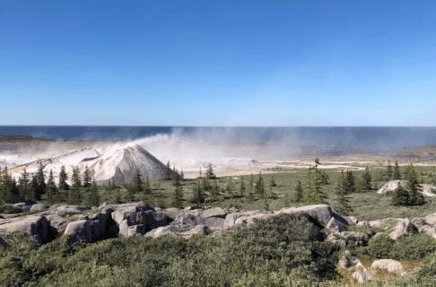
In 2022 a huge amount of Churchill quartzite was being crushed at Airport Cove, to provide ballast stone for improvements to the Hudson Bay Railway. 

Several individuals standing near the site of a ruined building. Some people look over the stone walls, now only a few feet high, into the ruin itself.

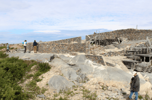
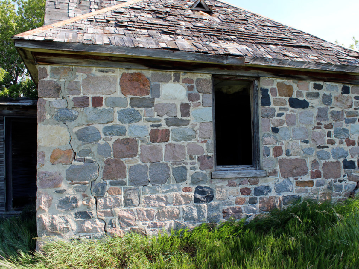
Some human usage of Churchill quartzite has been quite whimsical. This structure at Churchill, which looks like an ancient castle ruin, represents a never-completed stone hotel. The walls, built directly onto quartzite bedrock, include cobbles and boulders of many different kinds of stone. 

In the 20th and 21st centuries, Churchill quartzite has been put to many uses by enterprising humans: it makes superb ballast stone for the Hudson Bay Railway, it has been used to construct the large weir that controls flow of the Churchill River, it underlies the runways of Churchill Airport, and it appears as a backdrop in all those wonderful photos and videos of polar bears in their natural habitat! 

What does the future hold, I wonder, for such a remarkable and robust geological formation? In any case, it will be here for many millennia to come. 

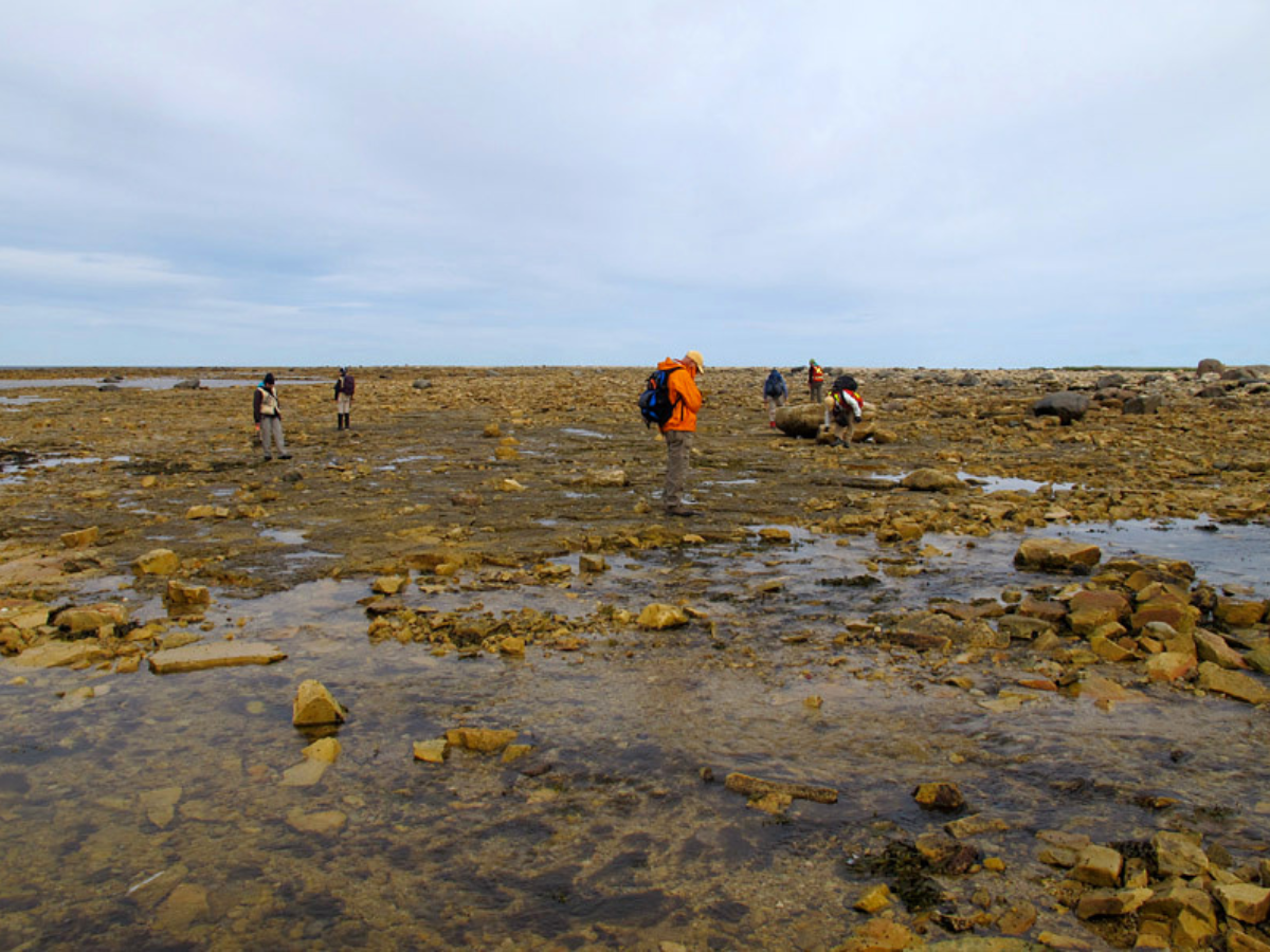
This post draws on images and observations from our very successful August, 2022, Museum research trip to the Churchill area, which allowed our group to develop many ideas for new exhibit collaborations. A few of the photos are from earlier paleontological fieldwork in the Churchill area over the past 26 years.  

Building Blocks of the Plains: A Fieldstone Wall in the Prairies Gallery 

By Dr. Graham Young, past Curator of Palaeontology & Geology


Beginning in 2012, The Museum’s curators worked together to plan exhibits for the Bringing Our Stories Forward project (BOSF). As we travelled around the grasslands region to prepare ideas for our new Prairies Gallery, we developed a list of topics that would be essential for a representation of this region. We rapidly agreed on some things that had to go into the Gallery: prairie vegetation, the importance of wind, Indigenous prehistory (and most particularly mound-building cultures), and several other topics. One of these was fieldstone. 


Photograph of the exterior wall of an abandoned stone house with an open window frame and a worn shingled roof.

A wall of the Brockinton house shows some of the geological variety of fieldstone types. 

What is fieldstone, and why did we think it was essential? 

When European settlers arrived on the prairies, they wanted to build permanent houses and other buildings. They were now in a region where there were almost no trees away from the river valleys, so material for wooden houses could be scarce. Many settlers came from parts of Europe where houses were built from stone that was quarried from solid bedrock, but on the Manitoba prairie the bedrock was either buried far below the land surface, or it was soft Cretaceous shale that was useless as a building stone. 

There was however, a building stone resource that was readily available: loose fieldstone boulders, which lay on the land surface or could be readily found by digging near riverbanks. Fieldstone is a mixture of many kinds of stone. These stones formed as bedrock at  different times, under varied conditions, and include igneous, metamorphic, and sedimentary rock types. 

A church building built of varied fieldstone with a distinctive black and red steeple.

Some fieldstone structures in southwestern Manitoba are much grander than the Brockinton house. These photos show St. Paul’s United Church in Boissevain, built as a Methodist church in 1893. 

Looking up at the wall of a fieldstone building with two windows side by side. At the bottom of the frame, above the doorway, a datestone reads “Methodist Church / 1893”.

Doorway of St. Paul’s United Church in Boissevain.

Like the settlers, fieldstone had immigrated to the prairies. During the Ice Age (Pleistocene Epoch), huge glaciers covered Manitoba. Glacial ice flowed southward, pulling blocks of stone out of solid bedrock. Blocks (glacial erratics), left behind when the ice melted, are used as fieldstone. Most fieldstone thus originated far to the north of where it is found today. 

Map graphic of Manitoba showing where in the province stones dating from certain ages came from to arrive at Bockington House in the south-western corner of the province.

Most fieldstone in southwest Manitoba comes from bedrock far to the north. This stone dates from the Precambrian (over 541 million years ago) and Paleozoic (541–252 million years ago) ages. In the Ice Age (2.6 million–10,000 years ago), the stones were picked up by glaciers and moved great distances.

Looking at a sandy bank with stones embedded in it. A short spade stands propped against the tall bank.

Fieldstone occurs with other sediment in glacial deposits, such as here in the Assiniboine River valley near St-Lazare. 

Close-up looking at the joints between stones in a fieldstone wall.

Fieldstone blocks of variable size are mortared together in a wall of the Brockinton house. 

Since fieldstone was a distinctive natural material seen across many parts of the prairies, and since it was used by settlers when they built many of the early buildings, it was clear to us that the fieldstone story should be included in our Prairies Gallery. We already planned to build an exhibit about the Brockinton National Historic site, a significant precontact bison kill site in the Souris Valley south of Melita, so it made sense that we also create an adjacent exhibit that would represent a wall of the Brockinton house, a late 19th century structure that sits at the top of the slope above the archaeological site. 

But how could we build this exhibit? Stone is really dense, and a mass of solid stone would have been far too heavy to be supported by the floor in our gallery space. Stone is also not really a topic that would have been suited to an animated video like our beautiful Prairies Mural Wall, and a flat panel display would have been just that: flat. We needed some way to allow visitors to observe and touch the genuine stone, in a setting that imitated a real fieldstone wall.  

Fortunately, in our various travels around southern Manitoba we had met Todd Braun, a stonemason who works in the Altona area. By consulting with Todd and with our exhibit design team, a plan took form: a frame would be fabricated from steel clad in plywood, and Todd would prepare the stones to attach to that frame, reducing their weight by slicing them thin. 

Large selection of blocks of fieldstone laid out in a cleared area on snowy ground.

These are some of the fieldstone blocks that had been chosen by Todd Braun as possible raw material for our fieldstone wall. 

A selection of fieldstone blocks laid out together in a general square shape.

The selected stones were laid out so that we could see how they would fit into the wall. 

A 3-D metal frame in a standing U shape in a workspace.

A steel framework was fabricated in three sections to serve as a “skeleton” for the wall structure. 

Todd and I selected stones to represent the great variety of fieldstone seen in southwestern Manitoba. Many of these came from boulders and cobbles that Todd had found during his visits to various gravel pits. A few were rocks that we found together, and in one or two instances I went to other geologists to request examples of very particular rock types.

Once we had agreed on the stones to be used, Todd prepared them using traditional techniques, breaking each rock with a hammer until it had a blocky shape. These blocks were laid out in their approximate relative positions for the wall. After a fitted layout was achieved, Todd patiently took each block and trimmed it with a saw so that the visible surface was effectively a “veneer” with only a few centimetres of thickness. These veneers were then attached to the steel and plywood frame using adhesives and metal hardware, and the space between them was covered in traditional mortar. The “corner stones” were a particular challenge, since they had to be cut in such a way that they would look like solid three dimensional blocks once the wall was assembled. 

Thinned blocks of fieldstone being laid out on a section of metal frame.

The wall sections were tipped on their side to allow the sliced stones to be placed. Note how the corner stones have been cut so that they will look like three-dimensional blocks. 

View underneath the 3-D metal frame, now lying flat with thinned fieldstone blocks placed on the surface. Inside it is hollow other than support beams.

This view from the underside shows the substantial steel structure that underlies the wall. 

The rectangular base of the frame now with fieldstone blocks attached, being lifted with chains by a tractor.

The completed base section of the wall is light enough to be lifted by Todd’s tractor. 

To allow the wall to be assembled in Todd’s workshop prior to its installation in our gallery, the frame was actually built in three sections. This made each piece light enough to be readily moved, and small enough to fit through the smallest doorway between the Museum’s loading dock and our new Prairies Gallery. Very early one morning, Todd arrived at the Museum with the completed wall sections on his trailer. These were hoisted into the loading dock, and rolled through the Museum to the wall’s permanent gallery location. Todd and our construction team had created an ingenious hoist system that would allow each upper wall section to be lifted into position on the base section. Once the wall sections were in place, they were bolted together, and Todd covered the joins with fresh mortar. 


Two “pillars” of frame with fieldstone attached to the exterior being moved into place in the new Prairies Gallery with a hoist and girder system.

In the Museum, the upper wall sections were attached to a hoist and girder system so that the base section could be wheeled into place beneath them. 

Two individuals pump up pallet jacks with the rectangular base of the metal frame and fieldstone wall on them.

The base section was rolled in on two pallet jacks. 

Three individuals maneuver the rectanulgar base of the metal frame and fieldstone wall under the two side pillars, which are hanging in place on a joist and girder system, using two pallet jacks.

The finished wall looks very much like the walls you can see at Brockinton House and on other buildings in southwest Manitoba, and it beautifully demonstrates both fieldstone construction and the geological variety of this fascinating material. As is the case for some other Museum exhibits, there is no evidence of the incredibly complicated and lengthy development and construction process that allowed this structure to “look like the real thing.” 

The constructed fieldstone wall in the new Prairies Gallery next to descriptive exhibit panels and other displays.

The finished wall is surrounded by interpretive materials, telling the fieldstone story. 

We have a new treasure and an unsolved mystery in the Anthropology Department

By Maureen Matthews 

Past Curator of Cultural Anthropology 

We would love to know who made this beautiful beadwork. 

A few years ago, Mrs. Arlene Kolb purchased this beaded panel in the Value Village shop on Regent Street because she loves handmade things. “I feel that the people making these items were content and focused on what they were doing. They put the effort into making something special,” she told me. After a year of enjoying it, she brought it to the Museum and it happened that there were a couple of Manitoba’s finest beading experts in the museum, Dr. Sherry Farrel Racette of the University of Manitoba Native Studies Department and Jennine Krauchi, one of our foremost beadwork artists. They took one look at the colours, the size of the beads and the pattern and confidently dated it to the 1830s or earlier and were pretty sure it was a Metis woman who made it. The colours of beads and fabric changed after the 1850′s with the introduction of analine dyes. The telltale beads on this piece are are a muted pink, a colour they call greasy yellow and facetted metal beads all of which predate analine dyes. 

Close-up of colourful, floral beaded panel

Please share this blog post with anyone who might know about the history of this marvelous beadwork because we would like to re-establish its broken family ties. 

Treaty Number One Medals at the Manitoba Museum tell a First Nations Story 

By Maureen Matthews 

Past Curator of Cultural Anthropology 

For the commemoration of the 150th Anniversary of Treaty Number One, three Treaty medals from the Manitoba Museum will be on display at Lower Fort Garry. Although these medals were used by Canada to acknowledge promises made by the Crown to First Nations people in Treaty negotiations, they also reveal a history of First Nations protocols, diplomacy, and political advocacy at a difficult time.[1] 

The gift of medals to honour mutual obligations in Manitoba began with the fur trade.  The first HBC Chief’s medal was created in 1776 by Thomas Hutchins, Hudson’s Bay Company (HBC) Chief Factor at Albany who found that among the Ininiwak who lived on the edge of Hudson’s Bay, there was an expectation that medals would be offered. Hutchins told the Governor of the company that “ … medals also are much esteemed amongst them if large, and if presented with ceremony when the Calimut [Calument or Pipe] is smoaked[sic], will be not only deemed a mark of distinction but perhaps be a means of binding the Leaders more securely in your Interest.” (quoted in Carter 2004). During and after the war of 1812, many First Nations leaders in Canada and the US were presented with medals featuring King George III in thanks for fighting with the British against the United States. By the time negotiations for the Numbered Treaties were initiated, medals were part of a 200 year long First Nations history of Treaty making and had been used to secure a range of mutual understandings, alliances, and friendships.  

Photograph of a Treaty Number 1 handshake medal. A circular silver medal portraying a representitive of England shaking hands with a First Nations leader. They stand on grassy ground in front of tipis and the rising sun. Text around the edge of the medal reads, “Indian Treaty No. 1 / 1873”.

When we talk about Treaty Number One, the image which comes to mind is the famous handshake medal shown here, but in fact this is not the medal that was offered in August 1871 when Treaty Number One was finalized. If you look carefully, you will see that this medal is dated 1873.  

The Treaty Commissioners who arrived from Ottawa in 1871 to negotiate Treaty Number One seem to have underestimated the importance of the gift of medals as a gesture of good faith and reassurance to First Nations leaders because the first medal they presented to the chiefs in 1871 was a smallish silver medal with an oak leaf wreath on one side and a standard image of the young Queen Victoria on the other. The medal was chosen from the existing stock of generic medals made by J.S. & A.B. Wyon of London, England. It was small, thin, and made no overt reference to the momentous nature of the Treaties it was meant to signify. The Chiefs who participated in the negotiations that year thought it looked a little too much like a prize at an agricultural fair, and after seven days of negotiations and months of preparation on the part of First Nations leaders, this non-descript Treaty medal seemed to the Chiefs to be an inadequate gesture. As an expression of intent, this generic medal must have worried the Chiefs because it left a feeling that Canada was not taking to heart the enormous implications of the Treaties. 

Photograph of a circular silver medal an oak leaf wreath. Medal is hung on a piece of purplish fabric or ribbon.
Photograph of circular silver medal with a likeness of young Queen Victoria. Text either side of the likeness reads, “Victoria Regina”. Medal is hung on a piece of purpleish fabric or ribbon.

The Treaty Commissioners, having registered the rebuff, returned to negotiations in 1872 with a much more dramatic medal. It was very large, 95 millimeters (almost 4 inches) in diameter, and was based on the medal struck to celebrate Canadian Confederation. The center circle has an image of Imperial Britannia as a Roman matron with a lion resting his chin on her lap and the four founding provinces, as Roman maidens, each hold a shovel, axe, paddle or scythe illustrating their province’s economic possibilities. Surrounding this Confederation image, the medal maker, a Canadian silversmith Robert Hendry of Montreal, added an 11-millimeter band which declared, on one side, “INDIANS OF THE NORTH WEST TERRITORIES,” and on the other – the side with the image of a slightly older Queen Victoria – “DOMINION OF CANADA / CHIEFS MEDAL 1872.” This medal was initially welcomed by the chiefs until it became apparent that it had been struck in copper and merely electroplated with a thin coat of silver. The Anishinaabemowin word for silver is zhooniyaawaabik, literally ‘money metal,’ and it matters if it is pure. When the silver began to peel and rub off, the Chiefs judged this medal a very shallow gesture on behalf of the Crown. 

Photograph of three silver medals. L-R: 1. The smallest medal; circular and decorated with an engraving of an oak leaf wreath; hung on a purplish piece of ribbon or fabric. 2. The largest medal; highly decorative, portaying a scene with Imperial Britannia, a lion, and Roman maidens; text around the edge of the medal reads, “Indians of the North West Territories / Juventas et Patrius Vigor / Canada Instaurata 1867”. 3. Final medal; the Treaty No. 1 handshake medal; a circular silver medal portraying a representitive of England shaking hands with a First Nations leader; they stand on grassy ground in front of tipis and the rising sun; text around the edge of the medal reads, “Indian Treaty No. 1 / 1873”.
Photograph of a highly decorative circular silver medal portaying a scene with Imperial Britannia, a lion, and Roman maidens clustered together. Text around the edge of the medal reads, “Indians of the North West Territories / Juventas et Patrius Vigor / Canada Instaurata 1867”. Text has been overlaid at the top of the image, reading, “1872 Treaty Medal”.
Photograph of a circular, silver medal with a likeness of Queen Victoria. Around the likeness text reads, “Victoria D : G: Britt : Reg : F : D”. Text around the edge of the medal reads, “Dominion of Canada / Chief’s Medal / 1872”

By the summer of 1873, the chiefs were restive, most particularly because oral promises made at the time of the first signing were not being written down on the Treaty documents, but also in protest that the 1872 medal had been yet another inadequate signifier of the sincerity of Canada’s promises. So it was in the summer of 1873 that the now famous 99 per cent pure silver medal with the handshake was commissioned. Like the first medal, this one was made in London, England, by J.S. & A.B. Wyon. The front features a bust of Queen Victoria and the inscription “VICTORIA REGINA.” The inscription on the reverse side reads: “INDIAN TREATY N°. –  and the date 187- .” The spaces were deliberately left blank and were incised with the Treaty number and date at the moment of concluding each successive Treaty. The handshake medal was used until Queen Victoria’s death, by which time relationships had taken such a negative turn that a hollow bronze medal with Edward VII on the back was accepted with little comment. 

Photograph of eight Treaty Medals on a black background. Top row is the front of each medal, bottom row is the back of each medal.

The handshake medal has come to resonate powerfully with First Nations peoples for the promise it holds, for the idea that a respectful relationship with the Crown will be restored. But the handshake medal is still a product of the 1870s, designed in London by an engraver who had never been to Canada and had certainly never met a Treaty Chief.

Photo credit: George V. Camera Press/Globe Photos Official portrait of King George V in uniform and wearing military medals.
Photograph of a Treaty Number 1 handshake medal. A circular silver medal portraying a representitive of England shaking hands with a First Nations leader. They stand on grassy ground in front of tipis and the rising sun. Text around the edge of the medal reads, “Indian Treaty No. 1 / 1873”.
Sephia-toned studio photograph of Chief Gaagige Binesi, Forever Thunderbird, also known as William Mann Sr.

The fully clothed figure on the left side of the medal, a representative of the Queen, resembles no one more than the Prince of Wales, later King George V, although the uniform is controversial. But with Queen Victoria on the back and someone who looks like the Prince on the front, the medal is a graphic confirmation that the Treaty relationship is between the Crown of England and First Nations. The bare-chested, feather-skirted Chief, on the other hand, is problematic. Photographs of Treaty events in 1873 show crowds of men dressed in suits and it is actually quite hard to pick out the Treaty Commissioner and his party unless they are up on a dias or have a chair to sit on, because everyone present is dressed the same. The chief on the medal does not seem to bear any relation to the First Nations leaders who made Treaty Number One. The adjacent photo is of Chief Gaagige Binesi, Forever Thunderbird, also known as William Mann Sr. who negotiated Treaty Number One on behalf of Sagkeeng First Nation. The large photo, taken and printed in the 1870s, shows Chief Gaagige Binesi wearing the original Treaty Number One Chief’s coat he received in 1871. Five generations of the Mann family looked after this photo. In 2012, 140 years after it had been taken, Ted Mann brought the photo to the Manitoba Museum asking that it be used to tell the story of his famous ancestor and his role in the making of Treaty Number One. The image actively foregrounds a strong, confident Treaty Chief and provides a corrective to colonial imagery that patronizingly romanticizes Indigenous peoples and undermines their authority.   

And where did this strange Indigenous imagery come from? It is probable that the engraver at Wyon in London was using as a model, an American Peace medal from the American Revolutionary War when George Washington was President. There were many iterations of this American medal over the years, but the feather skirt and strange feathers persist. 

An American peace medal portraying George Washington offering a long pipe to a First Nations Leader. Text at the bottom reads, “Geroge Washington / President / 1792”.

The handshake Treaty Medal is a part of First Nations Treaty history and the gesture of the tentative handshake suggesting equity alludes to a British way of making a promise. First Nations people have a long history of holding the Crown to account for these promises. And if the inescapable implication of the Treaty Chiefs is that First Nations participants in Treaty-making were “noble” but naïve, and probably incapable of understanding Treaties or their implications, the photo of Chief Forever Thunderbird provides a strong counter narrative to the racist image of primitive naiveté; the portrait shows that the chiefs negotiating the treaty were wise and thoughtful political figures. The handshake medals, as signifiers of the Treaty relationship, like the Treaties themselves, hold both the promise of sincere reciprocity and the dangers of racist condescension. 

[1] Others argue that the fact of the changes were made as the negotiations proceeded through each of the early numbered treaties – as new provisions for hunting rights, rights of occupation, and a medicine chest clause were added – is evidence that there was some significant degree of First Nations agency in the negotiations taking place. In an article looking at the change in view on Treaty No, 1, Hall cites the following historians: John Leonard Taylor (1975, 1979), Richard Price (1979), John Foster (1979), Hugh Dempsey (1978), and Chief John Snow (1977). See Hall who talks about the treaty negotiation during Treaty One here.  

Weird Tasks: Moving the Glyptodont 

By Dr. Graham Young, past Curator of Palaeontology & Geology


As we have worked our way through the pliosaur exhibit project, we have come up against a series of problems that have required novel solutions. About a month ago we carried out a very strange task, and one that none of us had ever had to do before: we needed to move the glyptodont. 

Before I explain how we did this, perhaps I had better backtrack a bit, as you probably have some questions at this point: “What is a glyptodont, anyway? Where did the Museum get its glyptodont and why did you need to move it?” 

A graphic illustration showing an individual standing next to a fossil of a creature with a large armoured shell and tail (Glyptodont) displayed on a raised platform.

The glyptodont, as featured in Ward’s catalogue from 1866. 

Black and white photograph of a museum gallery with many display cases and platforms. In the foreground, bottom left corner is a fossil of a creature with a large armoured shell and tail (Glyptondont) on its platform. In the background, upper right corner, is a large fossil standing on it’s hind legs with arms raised in front of it ( Megatherium) on its platform.

The Redpath Museum in 1925, showing both the glyptodont (left) and the ground sloth (right). (photo: McCord Museum).

Photograph looking into the Manitoba Museum Earth History Gallery from behind the display platform holding the Megatherium. In the background, to the right, is the glyptodont on its display platform near descriptive panels with illustrations of the globe.

The ground sloth and glyptodont, in their positions in the Earth History Gallery from 1973 to 2016.

Glyptodonts were creatures that lived during the Ice Age, that have been described as “fridge-size armadillos,” although the largest ones could perhaps have been called “armadillos the size of Volkswagen Bugs.” They were heavy, armoured creatures that weighed up to two tonnes. They spent their time lumbering around the forests and plains of South America and southern North America,  eating trees and grasses. Glyptodonts became extinct about 10,000 years ago during the “Quaternary Extinction Event,” at about the same time as giant ground sloths and other large mammals, probably as a result of climate change and hunting by humans. 

Our particular glyptodont is a replica of a fossil that belonged to the genus Glyptodon, and like our ground sloth it came to the Museum by a long and circuitous route. The glyptodont and the ground sloth were among the earliest casts of big vertebrate fossils, produced during the late 19th century by Ward’s Natural Science Establishment in Rochester, New York. Our ground sloth (Megatherium) was supplied to the Redpath Museum in Montreal in time for the opening of that institution in 1882, while the glyptodont joined it in Montreal some years later. 

By the 1960s, the Redpath was renovating, and these immense casts were removed and needed a home. The Manitoba Museum was under construction, so the casts were transferred to us and shipped to Winnipeg. They were assembled when the Earth History Gallery was constructed, and were there in time for the gallery opening in 1973. For the forty-plus years since then, both of these huge and historic casts have stood in place on the platforms that had been constructed for them. 

Now, in 2016, we are renovating that part of the gallery so that we can install our exciting fossil pliosaur, and to make space we have had to move the glyptodont. Since this replica had been in place since long before any of us worked here, we did not have any advance knowledge of how it should be handled, and since it is an irreplaceable artefact dating from  over a century ago, we considered this move with some trepidation. Since it turned out that the glyptodont is also immensely heavy, having been constructed of plaster, wood, and iron in the best 19th century fashion, our trepidation was well placed. 


Close-up photograph of the Glyptodont: a four-legged creature with a large, rounded, armoured shell, and thick armoured tail reaching the ground.

Detail of the glyptodont, as it was from 1973 to 2016.

As has been the case with handling the plesiosaur specimen, our technical staff love this sort of challenge, and Bert Valentin and Sean Workman had come up with solutions in the best “jury rigged” manner. Back when we installed our mineral exhibit, Bert had modified an engine hoist so that we could move our giant amethyst specimen, which weighs close to half a tonne. Now, with a fossil cast that weighs about the same amount (we weren’t able to weigh it, so this is a best guess), Bert re-modified that hoist as a glyptodont-lifter. The following sequence of photographs shows how it went – the process was much more nerve-wracking than it appears here! 

Two individuals sit either side of the Glyptodont watching as another individual works lying on the display platform under the shell.

Bert Valentin crawls under the glyptodont to saw the head off, while Janis Klapecki and Sean Workman assist. The head will be taken out for conservation work, while we move the glyptodont’s carapace. 

The Glyptodont shell from the side with beams under it and strapped either side of it ready to be lifted off its platform using an enginge hoist.

The engine hoist is placed over the glyptodont, which is attached by thick straps attached to steel beams. The long pieces of wooden rail will allow us to control the tipping of the carapace when it is unbolted from the platform. 

View from the front of the Glyptodont shell showing steel beams running insider it at either side and attached with thick yellow straps to the engine hoist above. Bubble wrap placed on the shell protects it from the friction of the straps.

An end-on view shows how the steel beams are passed under and through the glyptodont. 

A display platform with a large fossil standing on its hind legs with its tail stretching behind it (Megatherium). The fossil’s head and arms are out of frame. A wooden additon has been added to the platform to the right of the Megatherium and a cardboard cutout in the shape of the Glyptodont lies on the top of the new addition.

Marc Hebert had built this extension to the ground sloth’s platform. A cardboard cutout shows the location to which we will move the glyptodont. 

Three individuals work together to move a large Glyptodont carapace onto a wheeled cart from a platform using an engine hoist lift.

Before Sean can begin to hoist the replica, Bert adjusts the attachments. 

Four individuals work together around the Glyptodont carapace, now being moved using the engine hoist. They hold it steady either side of the carapace with wooden rails attached to the support beams running under the shell.

It is lifted, and the scary part of the operation begins! 

The engine hoist carrying the Glyptodont carapace backed against its ne platform space beside the Megatherium fossil. Three individuals work to keep it balanced as they move it.

Sean rolls the hoist, while Bert and I use the rails to keep the carapace steady. 

On the left, two individuals stand beside an engine hoist with the Glyptodont carapace strapped to it. On the right, Dr. Graham Young stands on the new platform looking down at where the Glyptodont is to be moved.

Contemplating just how we are going to swing that heavy fragile antique up onto the platform… 

One indivudal kneels at the back of the engine hoist to watch under the Glyptodont as two other individuals use the wooden rails strapped either side of the Glyptodont to guide it into place over the platform.

…and here we go, using the cart to prop the base supports. 

Four individuals works together to lift the Glyptodont carapace onto the wooden platform, holding the wooden rails stapped either end of it.

Traditional muscle power is used to slide the glyptodont to its final location. 

Two indivduals stand either end of the new platform looking at the Glyptodont carapace, now in place.

The replica is now attached in place, ready for the rest of the exhibit to be completed around it. 

Chief Piapot and the Qu’Appelle Treaty 

By Maureen Matthews 

Past Curator of Cultural Anthropology 

 This is an image of an original 1875 handwritten parchment document related to the signing of Treaty No. 4., the “Qu’appelle Treaty”, temporarily on display at the museum as part the “We are All Treaty People Exhibit”. Treaty No. 4 was originally concluded at Fort Qu’Appelle in 1874 but many Anishinaabe and Cree Chiefs were absent at the time. This fragile document sets out instructions for Treaty Commissioner William Christie to return to Fort Qu’Appelle in the summer of 1875 and ” secure the adhesion” of the remaining Chiefs. 

Among those Chiefs was Piapot, one of the most famous and powerful leaders of the Plains Cree. He wanted a reserve for his people in the Cypress Hills region of what is now South-Western Saskatchewan. Christie misled Piapot about the terms of the Treaty, and Piapot’s band were forced to settle more than two hundred and eighty miles to the east. This document initiated a train of events which led to a decades long enmity between Canadian officials and the Plains Cree of Piapot’s band. 

Close-up view of some of the artifacts featured in the “We Are All Treaty People” Exhibit: a wooden pipe and some tabacco laid on a pipe bag with beaded detailing. A Treaty No. 1 handshake medal.

Also featured in the “We are All Treaty People” exhibit is a peace pipe formerly owned by Piapot. The pipe was a gift of thanks to a minister who conducted the marriage of Piapot’s daughter.

The text of the document follows: 

Copy of a Report of a Committee of The Honourable The Privy Council 

Approved by His Excellency The Administrator of the Government in Council on the 9th of July 1875. 

A Memorandum dated 2nd of July, 1875, from, The Honourable the Minister of the Interior,  respecting the Treaty concluded at Qu’Appelle in September last with the Cree, Saulteaux and other Indians mentioned therein, provides among other things, that reserves be selected for the Indians affected by the Treaty by Officers appointed for that purpose; that the said Treaty further provides , that annual payments should be made to the Chiefs, Headmen and Heads of Families of the various Tribes , and also that presents of clothing and other articles shall be annually distributed among the different Bands included in the Treaty. 

That it appears to him desirable that steps should be taken for the selection during the present season, of the Reserves in question and that for provision to be made at once for the payment of the annuities and distribution of Presents  authorized to be distributed this year 

The Minister also represents that in consequence  of the absence of the Chiefs of certain of the Indian Bands affected by the said Treaty, their adhesion thereto has not as yet been obtained and thus it is important that they be brought into the Treaty as soon as practicable. 

He therefore recommends: 

 That William Joseph Christie, Esquire of Brockville, Ontario with the assistance of persons as may be named for the purpose by the Minister of the Interior be appointed to select the Reserves where they shall be determined most convenient and advantageous for the Indians , each reserve to be selected as provided by the Treaty after conference with the Band of Indians interested therein and subject to the conditions set forth in the Treaty.  

That the said, Mr. William Joseph Christie and the other person named as aforesaid by the Minister of the Interior to be authorized to pay the annuities and to distribute Clothing and other Presents authorized by the Qu’Appelle Treaty  and secure the adhesion of the Bands of Indians living within the territory covered by the Treaty and who either from absence or any other cause, were not parties to the Treaty concluded last year. 

The Committee submit the foregoing recommendation for your excellency’s approval. 

To The Honourable 

The Minister of the Interior Etc, etc, etc } 

Department of the Interior, Ottawa , 15 July 1875 

  1. J. Christie, Esquire                                      [signed] Minister of the Interior


Images: Parchment document HBC 1, Photo The Manitoba Museum 

Pipe, H4-42-6A, Pipe Bag, H 4-4-21-76, and Treaty Medal, HBC 57-53, Photo The Manitoba Museum. 

Dr. Amelia Fay

Dr. Amelia Fay

Curator of Anthropology & the HBC Museum Collection

Amelia Fay is Curator of Anthropology and the HBC Museum Collection at the Manitoba Museum. She received her BA in Anthropology from the University of Manitoba (2004), an MA in Archaeology…
Meet Dr. Amelia Fay

Left Behind in Airport Cove 

By Dr. Graham Young, past Curator of Palaeontology & Geology


If you think about how Museum paleontologists get fossils, you might guess that we go out and find where the fossils are, extract all of them from the rock and sediment, and return them to the Museum. Certainly that is what we do where fossils are scarce, but in many instances our job really consists of deciding what to leave behind. Our specialists at the Manitoba Museum are called curators, and a curator by definition has to be able to select what is needed for collections and exhibits. 

Photo looking out over a rock landscape with low pools of water. A group of indviduals are scattered around looking at the rocks

Our field group, walking across dolostone beds in the Silurian part of the cove.  

This fact was really brought home to me in the past couple of weeks, as we revisited sites in Airport Cove, the stretch of shoreline north of the airport at Churchill. Airport Cove covers a large area, with many patches of bedrock spread across the shoreline. These patches of rock allow us to sample many different sedimentary beds from the end of the Ordovician Period and the beginning of the Silurian Period, roughly 445-435 million years ago. 

Landscape view over a rocky stretch of ground leading to the open water in the distance.

In the cove, the rock seems to go on almost forever. 

The rocks in the cove were deposited as sediment in warm tropical seas, so fossils are plentiful in many of them. With such an embarrassment of riches we have to be selective every time we go out in the cove; if I collected every decent fossil, we would need an entire freight train to get them to Winnipeg!  And then, where could we possibly store them? 

Close-up on rock surface with two shell fossils embedded in it. A size scale card is placed in frame along the bottom.

Two examples of the large Silurian brachiopod (lamp shell) Virgiana decussata.

As a result of our previous work here, many examples of the “standard” fossils from Airport Cove are already resident in the Museum’s collections, and this time we were looking for very specific and rare things. So we would walk around the cove each day, considering and photographing the more common sorts of fossils. Some of these are old friends, on blocks of stone that I can remember being in the same place ten or fifteen years ago. Others were new to me, but I can hope to see them again if I get back here. And then there are the few fossils that are so good that they must go to the Museum; one of these is shown at the end of this piece. 

Close-up photo of a section of rock with many small fossil pieces embedded in it. A size scale card is placed in frame along the top.

Abundant pieces of auloporids, Silurian “organ pipe” corals, in a dolostone bed low in the modern intertidal zone.

If you are ever in the Churchill area and wish to go looking for fossils, please follow all  guidelines on polar bear safety! We had to leave our work area at Airport Cove twice last week as there were bears nearby, and on one occasion a mother and cub walked right through our site very shortly after we got into the truck. 

Photograph of a section of rock with an elongated tube-shaped fossil in the surface. A size scale card is placed on the rock beside the fossil.

Old friends: we have been walking past this block of Ordovician stone for the past fifteen years or more. The elongate fossil on the left is the central tube (siphuncle) of a nautiloid cephalopod, while that on the right is an tall aulacerid stromatoporoid (sponge). 

Close-up photo of a section of rock with a curved U shaped fossil in the surface. A size scale card is placed in frame along the top.

The pygidium (tail) of the Ordovician trilobite Isotelus.

Close-up photo of a section of rock with dark lichens growing on the surface. Two fossils are embedded in the rock, on round and swirled, the other rounded on one side. A size scale card is placed in frame along the left edge.

Another example of the gastropod Maclurina manitobensis (lower), with an unidentified fossil that might be a stromatoporoid sponge.

A section of rock with half of a round, swirled fossil embedded in it. A quarter is placed on the rock’s surface for scale.

The one we couldn’t leave behind: this beautiful Ordovician coiled nautiloid cephalopod is now in transit to Winnipeg, along with the other fossils we collected. 

Landscape photograph looking out over a rocky shoreline at the water’s edge.

The end of the cove.

The Fossils Surround Us 

By Dr. Graham Young, past Curator of Palaeontology & Geology


Those of us who live in Winnipeg know that fossils are never far away. Many Winnipeg structures feature surfaces clad in Tyndall Stone, a fossil-rich dolomitic limestone of Late Ordovician age (about 450 million years old). Tyndall Stone covers public buildings such as the Manitoba Legislative Building and the Winnipeg Art Gallery, and commercial buildings in the downtown core, but it can also be seen in thousands of homes in Winnipeg: in walls, steps, and fireplaces. 

Thus, it is hardly surprising that the Museum and the adjacent Centennial Concert Hall both use Tyndall Stone inside and out. Of course Tyndall Stone fossils are represented in our Earth History Gallery, but if you think about it, it is odd that there are so many more “museum-grade specimens” exposed to the weather on the outside of the building. On the inside, as these photos show, we sometimes cover up beautiful fossils with the detritus of everyday existence: signs, fountains, alarms, and thermostats. In part, this is because the fossils are so abundant that it is hard to avoid them when placing objects, but it may also be that they are so commonplace here that people ignore them and take them for granted. 

Maybe someday we will add interpretative signage to some of the better and more accessible fossils on and in the Museum, but that would be a big project to undertake. In the meantime, here is a sampling of a few of the good ones.

Photograph of a Tyndall Stone wall with intermitant fossils embedded in it, and an EXIT sign in the upper right corner.

The hallway near the elevators may look like an unprepossessing remnant of the 1960s, but those mottled walls are thin slabs of Tyndall Stone. This stone, quarried by Gillis Quarries Limited at Garson, Manitoba,  is rich in fossils representing life from an ancient tropical seafloor. 

Close-up of a clock fixed to a Tyndall Stone wall with a white fossil under the bottom left corner of the clock.

Geologically, Tyndall Stone is part of the Selkirk Member of the Red River Formation; this bedrock formation underlies much of southern Manitoba, but it is only exposed in certain places such as in cliffs along Lake Winnipeg, and in the Tyndall Stone Quarries at Garson. Behind this clock, the darker mottles represent burrows in the ancient seafloor, made by millions of little arthropods or worms. The white structure to the lower left is the colonial coral Protrochiscolithus. 

Close-up on a emergency “Break Glass for Key” fixture attached to a Tyndall Stone wall. Beneath the fixture is a large rounded fossil of a stromatoporoid sponge.

The big brown blob beside the elevator is a stromatoporoid sponge. To its lower right, a smaller dome-shaped stromatoporoid (brown dome) was encrusted by the tabulate coral Protrochiscolithus (white), and to the right is a honeycomb rugose coral (Crenulites?). 

Close-up photo of a Tyndall Stone wall. On the left, edge a red fire alarm box is fixed to the wall. To the right, is a horn-shaped fossil of the chain coral Catenipora.

The pattern in the upper right represents the chain coral Catenipora, which grew on the ancient seafloor (a place with no risk of fire!). 

Close-up of a water fountain. On its left, at the edge of the frame, is a small, light-coloured fossil.

The white thing beside the water fountain is an excellent example of a rugose coral (horn coral). 

Close -up of a light and bell alarm fixture in a Tyndall Stone wall. Below is is a dome-shaped fossil of the colonial coral Protrochiscolithus.

The ancient seafloor was mostly soft and muddy, but many of the creatures required firm or hard substrates. Since substrate was at a premium, animals often grew on top of one another. The dome-shaped structure to the lower left in this photo represents the colonial coral Protrochiscolithus (white part), which grew on top of a stromatoporoid sponge (brown part). 

Close-up of a thermostat fixed to a Tyndall Stone wall partially covering a horn-shaped fossil cephalopod.

As common as dirt: there are so many fossils in these walls that some very good ones, such as this cephalopod, have been covered by things like this thermostat. 

Photograph looking up a tall exterior wall made of Tydnall Stone.

Since there are so many fossils in the relatively small area of the foyer walls, imagine how many there are on the outside of the Museum!